Bestand:Cyprus CIA-WF 2010 map.png
Geen hogere resolutie beschikbaar.
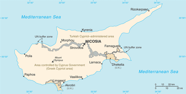
Cyprus_CIA-WF_2010_map.png (629 × 320 pixels, bestandsgrootte: 19 kB, MIME-type: image/png)
Dit is een bestand van Wikimedia Commons. Onderstaande beschrijving komt van de beschrijving van het bestand daar.
Commons is een vrij-gelicenceerde database voor afbeeldingen, geluid, video en andere bestanden. |
Beschrijving
| Beschrijving | Cyprus map from CIA World Factbook (since 4 juli 2010), converted from original GIF format |
| Datum | |
| Bron |
CIA World Factbook |
| Auteur | United States Central Intelligence Agency |
| Andere versies |
|
Licentie
Deze afbeelding bevindt zich in het publiek domein omdat het materiaal bevat dat oorspronkelijk afkomstig is van het CIA World Factbook.
|
 |
Bestandsgeschiedenis
Klik op een datum/tijd om het bestand te zien zoals het destijds was.
| Datum/tijd | Miniatuur | Afmetingen | Gebruiker | Opmerking | |
|---|---|---|---|---|---|
| huidige versie | 30 okt 2021 19:05 | | 629 × 320 (19 kB) | Lojwe | Cropped 1 % horizontally, 1 % vertically using CropTool with precise mode. |
| 23 sep 2011 08:49 |  | 634 × 324 (21 kB) | Zyxw | == {{int:filedesc}} == {{Information | Description = {{w|Cyprus}} map from CIA World Factbook ([http://web.archive.org/web/20100704022834/https://www.cia.gov/library/publications/the-world-factbook/geos/cy.html since {{date|2010|07|04}}]), converted from |
Bestandsgebruik
Dit bestand wordt op de volgende pagina gebruikt:
Globaal bestandsgebruik
De volgende andere wiki's gebruiken dit bestand:
- Gebruikt op az.wikipedia.org
- Gebruikt op be-tarask.wikipedia.org
- Gebruikt op bg.wikipedia.org
- Gebruikt op bn.wikipedia.org
- Gebruikt op ca.wikipedia.org
- Gebruikt op diq.wikipedia.org
- Gebruikt op el.wikipedia.org
- Gebruikt op en.wikipedia.org
- Gebruikt op es.wikipedia.org
- Gebruikt op fa.wikipedia.org
- Gebruikt op fi.wikipedia.org
- Gebruikt op fur.wikipedia.org
- Gebruikt op id.wikipedia.org
- Gebruikt op ilo.wikipedia.org
- Gebruikt op it.wikipedia.org
- Gebruikt op ja.wikipedia.org
- Gebruikt op kn.wikipedia.org
- Gebruikt op lld.wikipedia.org
- Gebruikt op ml.wikipedia.org
- Gebruikt op or.wikipedia.org
- Gebruikt op pl.wikipedia.org
- Gebruikt op ru.wikipedia.org
- Gebruikt op simple.wikipedia.org
- Gebruikt op si.wikipedia.org
- Gebruikt op sl.wikipedia.org
- Gebruikt op th.wikipedia.org
- Gebruikt op tl.wikipedia.org
- Gebruikt op ur.wikipedia.org
- Gebruikt op uz.wikipedia.org
Globaal gebruik van dit bestand bekijken.