Bestand:Ternate (City), Indonesia (2010).jpg

Grootte van deze voorvertoning: 800 × 600 pixels. Andere resoluties: 320 × 240 pixels | 640 × 480 pixels | 1.024 × 768 pixels | 1.280 × 960 pixels | 2.560 × 1.920 pixels | 4.000 × 3.000 pixels.
Oorspronkelijk bestand (4.000 × 3.000 pixels, bestandsgrootte: 2,76 MB, MIME-type: image/jpeg)
Dit is een bestand van Wikimedia Commons. Onderstaande beschrijving komt van de beschrijving van het bestand daar.
Commons is een vrij-gelicenceerde database voor afbeeldingen, geluid, video en andere bestanden. |
,_Indonesia_(2010).jpg)
Beschrijving
| Beschrijving |
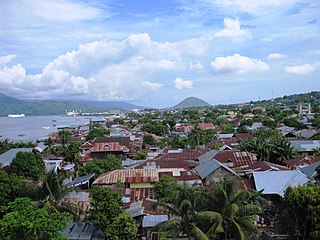
Deutsch: Kota Ternate Richtung Süden. Im Hintergrund der 1730 Meter hohe Vulkan Keimatubu der Nachbarinsel Tidore. Aufnahme durch den US-Diplomaten Tom Weinz nach der Ankunft des Hospitalsschiffs USNS Mercy im Rahmen der Pacific Partnership 2010 in Ternate.
English: Ternate City, located on the island of the same name, is the former administrative centre of North Maluku Province, Indonesia. U.S. Foreign Service Liaison Officer Tom Weinz captures a photo as the USNS Mercy for Pacific Partnership 2010 arrives in Ternate, Indonesia, on July 18, 2010.
Français : Ternate City, sur l'île de Ternate, est l'ancien centre administratif de la province des Moluques du Nord. |
| Datum | |
| Bron | https://www.flickr.com/photos/statephotos/4811774905/ |
| Auteur | U.S. Foreign Service Liaison Officer Tom Weinz |
| Andere versies |
| Cameralocatie | | Deze en andere afbeeldingen in: OpenStreetMap |
|---|
,_Indonesia_(2010).jpg¶ms=000.813475_N_0127.388278_E_globe:Earth_type:camera_region:ID_heading:180.00&language=nl)
Licentie
| This image is a work of a United States Department of State employee, taken or made as part of that person's official duties. As a work of the U.S. federal government, the image is in the public domain per 17 U.S.C. § 101 and § 105 and the Department Copyright Information. |  |
| Deze afbeelding is oorspronkelijk op Flickr geplaatst door U.S. Department of State op https://flickr.com/photos/9364837@N06/4811774905. Dit is op 16 augustus 2017 door de FlickreviewR-Bot beoordeeld en de licentie onder de voorwaarden van United States Government Work is bevestigd. |

|
Deze afbeelding is beoordeeld op basis van de criteria voor waardevolle afbeeldingen en wordt beschouwd als de meest waardevolle afbeelding op Commons binnen het onderwerpgebied: Ternate City, Indonesia. Deze nominatie kan bekeken worden op Commons:Valued image candidates/Ternate (City), Indonesia (2010).jpg. |
,_Indonesia_(2010).jpg)
Bestandsgeschiedenis
Klik op een datum/tijd om het bestand te zien zoals het destijds was.
| Datum/tijd | Miniatuur | Afmetingen | Gebruiker | Opmerking | |
|---|---|---|---|---|---|
| huidige versie | 1 aug 2010 18:44 | | 4.000 × 3.000 (2,76 MB) | Wikifreund | {{Information |Description=U.S. Foreign Service Liaison Officer Tom Weinz captures a photo as the USNS Mercy for Pacific Partnership 2010 arrives in Ternate, Indonesia, on July 18, 2010. |Source=http://www.flickr.com/photos/statephotos/4811774905/ |Date=2 |
Bestandsgebruik
Geen enkele pagina gebruikt dit bestand.
Globaal bestandsgebruik
De volgende andere wiki's gebruiken dit bestand:
- Gebruikt op ar.wikipedia.org
- Gebruikt op ceb.wikipedia.org
- Gebruikt op ce.wikipedia.org
- Gebruikt op de.wikipedia.org
- Gebruikt op en.wikivoyage.org
- Gebruikt op eo.wikipedia.org
- Gebruikt op et.wikipedia.org
- Gebruikt op he.wikipedia.org
- Gebruikt op he.wikiquote.org
- Gebruikt op id.wikipedia.org
- Gebruikt op incubator.wikimedia.org
- Gebruikt op ja.wikipedia.org
- Gebruikt op ko.wikipedia.org
- Gebruikt op lt.wikipedia.org
- Gebruikt op min.wikipedia.org
- Gebruikt op ml.wikipedia.org
- Gebruikt op nl.wikipedia.org
- Gebruikt op pl.wikipedia.org
- Gebruikt op pl.wikivoyage.org
- Gebruikt op ru.wikipedia.org
- Gebruikt op sv.wikipedia.org
- Gebruikt op tay.wikipedia.org
- Gebruikt op tt.wikipedia.org
- Gebruikt op uk.wikipedia.org
- Gebruikt op www.wikidata.org
- Gebruikt op zh.wikipedia.org
,_Indonesia_(2010).jpg)